

About the LINEAR PARK (Rail Trail)
next to our house


Original Owner: New Haven & Northampton Railroad
Most commonly known owner: New Haven Railroad (Williamsburg Branch of the New Haven RR)
Corridor acquired:: 1866
Built: 1867-1868
Open: 1869
Last Passenger Train: 1922.
Abandoned: Williamsburg to Leeds VA Center 1962;
Abandoned: Leeds to Florence and into Easthampton, 1969.
First proposed to convert to a bike path: 1976
Ribbon cutting as the City of Northampton's Ryan Bikeway: 1982
The New Haven Railroad's Canal Branch came up out of Connecticut, entering Massachusetts at Southwick. As it came into Northampton, it joined with the B&M at the beautiful Richardson-designed station, which today is the Depot Restaurant. Both roads then headed north for a short distance and then the NH branched away where the Acme Auto Body on King St. is currently located.
Remains of the footings for the overpass over Route 5 are still visible where the line once headed toward what is now Super Stop & Shop. This commercial development, and the others just north of here, sit atop what was once the New Haven's classification yard and engine service facilities, complete with turntable and coaling tower. A branch from this yard led to Williamsburg.
In 1962, during the last bankruptcy of the New Haven Railroad, a 5-mile segment of the branch was abandoned from the terminus at Williamsburg into Florence. Florence still had viable customers, one of which was a coal-fired power plant at the Veterans Hospital, which still received inbound shipments of coal.
In 1969, the conversion of the plant to natural gas--and the conversion of the Smith College and the State Hospital power plants to gas as well--caused the successor railroad, the infamous Penn-Central, to abandon service all the way back to downtown Easthampton. In 1971, the entire branch was sold to Massachusetts Electric Company.
In the mid 1970s, the City of Northampton decided to run a sewer line down the right of way and at the same time create a bikeway on the bed of the old railroad. After many meetings and dealing with comments of concern from the neighbors, the bikeway opened in 1984, making this rail trail one of the oldest municipally operated rail trails in the region. Today it is known as a section of the Mass Central Rail Trail.
Here's a few interesting views of the neighborhood in Florence. On the left is the old Florence Passenger Station. Torn down in 1965, this view shows the bleak situation in both the right-of-way and the station. The old Norwood Engineering Company is in the background. Today the station is obviously gone, but it is the location of Florence Paint and Decorating Center. The Norwood Engineering complex is fully restored, owned by Sam Ostroff and is the home of many small businesses including Salmon Studios..
The lower photos show the railroad corridor in Florence in both the 1930s (left) and the 1950s (right). Norwood can be seen in both photos, as well as the old coal tipple and Florence Casket Company which is still in business and is one of only a handful of family-owned independent casket manufacturers still in operation in the country.
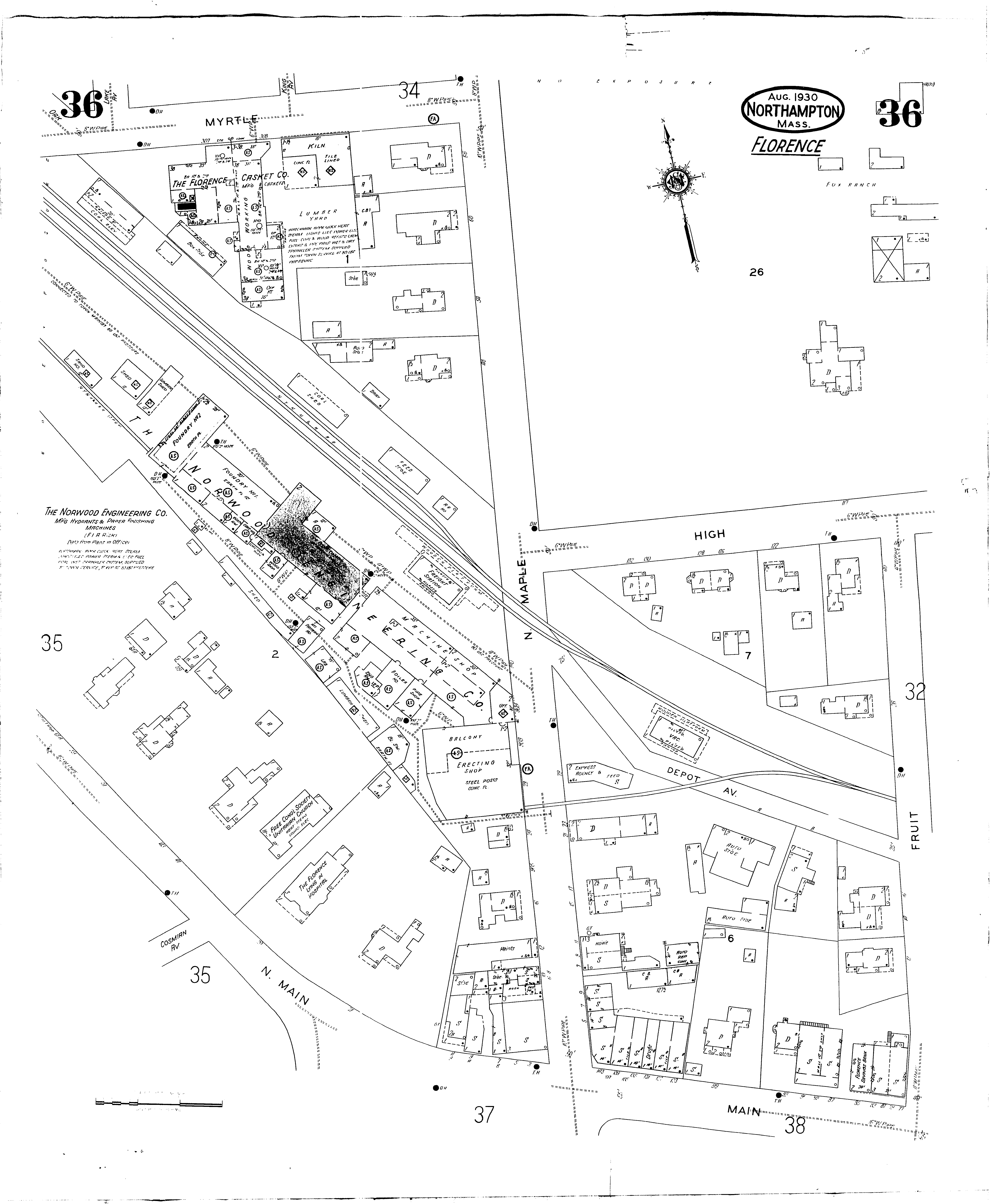
YESTERDAY’S MAPS ARE USEFUL FOR TODAY
During World War I, the U.S. railroads became gridlocked with war related traffic to such a degree that they literally ground to a halt. The federal government then stepped-in and "nationalized" or took over the entire system for the duration of the war.
Among the things they did was inventory everything that the railroads owned. This included inventorying every rail car, every wrench, every nut, every bolt, and an inventory of all the land and how it was obtained. This land inventory became known as the valuation maps—or "val maps"—for short. Not only did the val maps lay out the route of the railroad through a community, the maps also gave locations of every structure near the railroad tracks, number of tracks, location and length of sidings, bridges, culverts, etc.
Copies of val maps are kept at a number locations:
-
The current owning railroad’s real estate department has complete sets.
-
County Hall of Records usually have those in their district.
-
Railroad historical societies usually have most if not all of them.
-
Dealers in "railroadania" or railroad paper documents.
They are still useful today for a number of reasons:
How the land of the railroad was acquired in terms of deeds.
Location of possible areas of contamination or "brownfields."
The Florence val map shows the location of 3 coal sheds and 2 railroad sidings--or spur track--going into the property of Norwood Engineering Company (Norwood is now the location of Salmon Studios as noted above.) It also shows a scale for weighing horse-drawn wagons, a yard complex that was 4 tracks wide, and both a freight house and a passenger station.
The background here is a copy of one of the valuation maps (and other railroadania) that are on display in the Inn along with a large selection of rare books about the general history of the neighborhood.


Click here for a presentation about some railroad
history of the area.
